


Northern Star
-
Posts
705 -
Joined
-
Last visited
Content Type
Profiles
Forums
Character Archive
Frequently Asked Questions
Equestrian Empire Character Archive
Golden Oaks Memorial Library
Pony Roleplay Characters
Events
Blogs
Status Replies posted by Northern Star
-
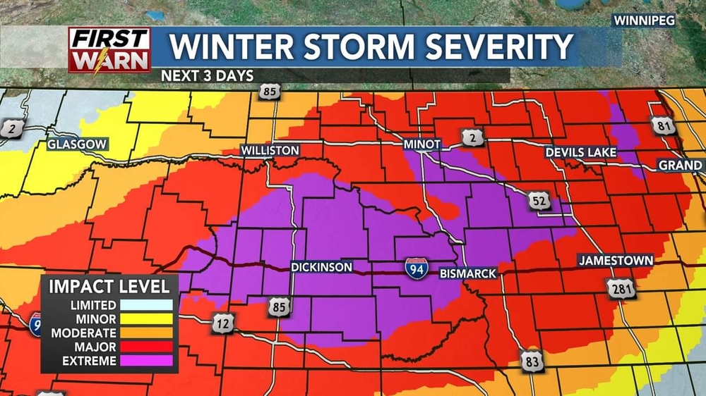
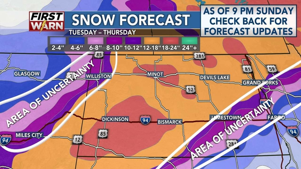
Like every spring, they say a big storm is on the way. Estimates have already been cut in half so I guess we will see.
They were saying 40+ inches and now...24 at the absolute worst.
Hopefully there is no wind and it's slow so it actually does some good.
-

Ah. I suspose it is rather warm down there. Yesterday here it was in the 60s, now we're down into the 20s.
That last picture I pulled from a Minnesota meme page as...well that is basically Northern Plains forecasts in a nutshell. Many meteorologists have said if you want to always be wrong, go forcast on the Northern Plains.
On a different note, I have seen one forcast say 100 inches, but I doubt that.
Otherwise usual snowfall for us is around 130" I think, as the last big snow winter we had 200"+ records.
-
-
Like every spring, they say a big storm is on the way. Estimates have already been cut in half so I guess we will see.
They were saying 40+ inches and now...24 at the absolute worst.
Hopefully there is no wind and it's slow so it actually does some good.
-
Like every spring, they say a big storm is on the way. Estimates have already been cut in half so I guess we will see.
They were saying 40+ inches and now...24 at the absolute worst.
Hopefully there is no wind and it's slow so it actually does some good.
-
@Kyoshi yep, North Dakota. Supposedly going SW to NE. Everyone has their own prediction on this system so I don't really know what to think about it. Last week they had 60", then 40", then 38 then 18, now some are raising it again. Supposedly it hasn't made it over the mountains yet either.
I'm in an "extreme" area. The generators are ready to go last I checked, so that's about all we can do I guess. Hoping for little wind and alot of heavy wet snow. We are a couple feet short on moisture still, so fires are more of a concern right now.
-
-
Like every spring, they say a big storm is on the way. Estimates have already been cut in half so I guess we will see.
They were saying 40+ inches and now...24 at the absolute worst.
Hopefully there is no wind and it's slow so it actually does some good.
-
Alright, here's the answer to the trivia question from Saturday/Sunday.
Sticking with Geography here. The counties/equivalencies of the US come in many shapes and sizes. Which of the following counties is the largest (as in the physical size) in the US?
Answer: D. San Bernardino County, California is the largest county in the US on terms of physical size, measuring 20,105 square miles from the mountains east of Los Angeles all the way to the eastern border of California.
Monday/Tuesday's questionGoing back to meteorology with this one. What is the parameter that measures the change in wind direction with height in the atmosphere and/or wind speed with height?
A: CAPE (Convective Available Potential Energy)
B: Significant Tornado Parameter
C: Wind Shear
D: CIN (Convective Inhibition)
Answer will be posted at approximately 10 pm CDT Tuesday. -
Alright, here's the answer to the trivia question from Tuesday/Wednesday.
Sticking with Geography here. The US states/territories are subdivided into counties/equivalencies. How many of these are there in the US?
Answer: C. A grand total of 3,243 counties/equivalencies are spread throughout the 50 states and territories of the US. Texas has the most at more than 200, and Delaware has the least, at 3.
Thursday/Friday's questionSticking with Geography here. The counties/equivalencies of the US come in many shapes and sizes. Which of the following counties is the smallest in the US?
A: Kalawao County, Hawaii
B: Arlington County, Virginia
C: Nantucket County, Massachusetts
D: Bronx County, New York
Answer will be posted at approximately 10 pm CDT Friday. -
Alright, here's the answer to the trivia question from Friday/Saturday
Continuing with weather here. Which of the following tornadoes produced the most damage (in dollar amounts)?
Answer: A. The 2011 Joplin, MO EF5 produced $2.8 billion dollars in damage.
The long track EF4 that hit Washington, IL on November 17th, 2013 produced $935 million dollars in damage.
THe 1999 Bridge Creek/Moore F5 (also known for the highest wind gust ever recorded) produced $1 billion dollars in damage.
The 1996 Decatur, IL F3 produced $6 million dollars in damage, and was included here because it was the tornado that sparked my interest in weather.
Sunday/Monday's questionGoing to geography here. It's common knowledge that the Mississippi RIver is the longest river in the US. What's the second longest river in the US?
A: Ohio RIver
B: Missouri RIver
C: Hudson River
D: La Moine River
Answer will be posted at approximately 10 pm CDT Monday. -
Alright, here's the answer to the trivia question from Monday/Tuesday.
Continuing with weather here. With the latest wave of tech advances, the National Weather Service has modernized the radar network. Which of the following advances has been added since 2012?
Answer: B. Dual Polarization (beams that go both horizontally and vertically) allows radar to detect debris in tornadoes as it is lifted into the air.
A and D are early radar advances. A came in the 1970s, with Nexrad (the NOAA next gen radars) coming in the late 1980s/1990s.
C is the next step in radar technology.
Friday/Saturday's questionContinuing with weather here. Which of the following tornadoes produced the most damage (in dollar amounts)?
A: The 2011 Joplin, MO EF5
B: The 2013 Long Track Washington, IL EF4
C: THe 1999 Bridge Creek/Moore F5
D: The 1996 Decatur, IL F3
Answer will be posted at approximately 10 pm CDT Saturday. -
Alright, here's the answer to the trivia question from Monday/Tuesday.
Continuing with weather here. What is a Radar Gap?
Answer: A. This was a bit of a meatball here. Radar gaps are regions of the US that aren't served by radar coverage at at least the 10,000 feet level. These are a major issue, especially in the central plains and midwest as the lack of coverage can prevent timely warning for tornadoes and severe thunderstorms.
Saturday/Sunday's questionContinuing with weather here. With the latest wave of tech advances, the National Weather Service has modernized the radar network. Which of the following advances has been added since 2012?
A: Doppler Radar/wind velocity
B: Dual Polarization
C: Pulse polarization
D: Nexrad capability
Answer will be posted at approximately 10 pm CDT Thursday. -
You all hear about the Oscars? I think Spider-Man was robbed to be honest.
 And that slap? I don't think that will do well for Chris and Will's careers.
  I wonder how people would react if the Oscar for Best Actor got taken off him because of that.
  I'd have given it to Andrew Garfield.
Anyway, good morning everypony!
 Have a great day!

-
Alright, here's the answer to the trivia question from Saturday/Sunday.
Going to meteorology. Up to 1950, the word tornado was banned from official weather forecasts. But shortly after it was allowed with the advancements of early radar. What town was the first that saw a tornado detected by radar?
Answer: D. On April 9th, 1953, the first recorded radar observations of a supercell thunderstorm were recorded at Champaign, IL via an experimental radar from the Illinois State Water Survey. THis would be the start of the march toward the radar technology we have in the US today.
Saturday/Sunday's questionContinuing with weather here. What is a Radar Gap?
A: An area/areas not adequately covered by NOAA's network of weather radar
B: areas that see more rain than others
C: areas that see more tornadoes than others
D: A storm that puts down large hail.
Answer will be posted at approximately 10 pm CDT Tuesday. -
You know what the worst designed device is? Old electrical panels! It bogggles my mind how a human with a brain thought these were good designs.
-
Alright, here's the answer to the trivia question from Tuesday/Wednesday.
Sticking with geography. Which of the following rivers within the state of Illinois is the longest?
Answer: D. The Kaskaskia River is a tributary of the Mississippi River that flows from agricultural fields in western Champaign county to its confluence with the Mississippi near Chester, IL, a course of 325 miles.
THe Sangamon river is the longest tributary of the Illinois RIver, snaking its way across central Illinois on a path approximately 246 miles from its headwaters in southeast McLean County, IL to the confluence at Beardstown, IL.
The Big Muddy River runs from southeast Jefferson County, Illinois to it's confluence with the Mississippi River southwest of Murphysboro, IL for a total distance of 156 miles.
The Illinois River runs from the confluence of the Kankakee and Des RIvers and runs down the spine of west central Illinois down to Grafton, IL where it has its confluence with the Mississippi RIver for a grand total of 273 miles.
Thursday/Friday's questionSticking with geography. Which of the following man-made lakes in the state of Illinois is the biggest?
A: Lake Shelbyville
B: Carlyle Lake
C: Sangchris Lake
D: Lake Taylorville
Answer will be posted at approximately 10 pm CDT Friday. -
Alright, here's the answer to the trivia question from Thursday/Friday.
Got one more weather question here. Which of the following tropical storm/hurricane names have NOT been retired?
Answer: D. Fred was a fairly weak tropical storm that impacted many of the Caribbean Islands and the gulf coast side of Florida in August 2021.
Hurricane Gustav was a Cat 4 hurricane that lashed part of the Caribbean and western tip of Cuba before making landfall in Louisiana with abundant heavy rainfall along the Mississippi River valley during late August and early September 2009.
Tropical Storm Allison is known for dumping copius amounts of rain over Texas and parts of the deep south, and is a great analog for the 'brown ocean effect' (storms remaining strong over land due to copious rainfall) in June 2001.
Hurricane Dorian was an extremely damaging cat 5 major hurricane that impacted the Bahamas and the eastern seaboard of the US and Canada.
Sunday/Monday's questionGoing back to geography. Which of the following states has the most counties/county equivalents by number in the US?
A: Texas
B: Georgia
C: Illinois
D: Kansas
Answer will be posted at approximately 10 pm CST Monday. -
Heya
-
Well technically no one uses Imperial anymore, aside from a few people in the UK and their colonies.
The US system is in use in the US and Liberia(as it was/is/still a US...territory colony...long story).
There is a small difference, mostly with liquids but a little bit on distances(depending on the revision) between the US and Imperial systems.
Burma uses it's own system, US, Imperial, and metric...but calls it their own system...
-
-
Heya
-
Wait am I reading something wrong?
First was "only one country...that doesn't use the metric system" and then you said "those places use the Imperial system"...so...
I mean if you want to get really technical, no one uses the Imperial system any more, just the US system and the Metric system, even though that is somewhat off topic.
-
-
Heya
-
@Samurai Equine you forgot Liberia(US's colony) and Burma.
Hello
-
-
Alright, here's the answer to the trivia question from Thursday/Friday
ONe more state trivia for Illinois. Every state in the US has an official state bird. Which of the following is Illinois' State bird?
Answer: D. The Northern Cardinal is the state bird of Illinois, along with a handful of other states.
Saturday/Sunday's questionGoing back to weather for this one. This weekend, a bomb cyclone will impact the eastern seaboard with tornadic thunderstorms, heavy rain, heavy snow, and very windy conditions. What is a bomb cyclone?
A: A low pressure that experiences a pressure drop of at least 24 millibars in 24 hours
B: A extratropical term for a hurricane
C: A strong snowstorm
D: Another term for a tornado outbreak
Answer will be posted at approximately 10 pm CST Sunday -
Random fact of the day: Apparently the government has decided that the town I live near and the associated river are called an offensive name and must change by the summer, to one of their approved names. Which are all already in use near by. And none make sense.
Like the proposed river names, they all contain "butte" or "mountain " like "Tommy mountain ". For the river name, and yes they said that was correct, if chosen the they'll call the river the "Tommy mountain ", river not included in the name.
The town names are worse, such as "settlement 348", and "western east fork of the (chosen river name) settlement gulch" . I'm not kidding either. Imagine saying you live in "settlement 348, next to the river called "Tommy mountain "" what type of names are those? Who thought of them?
And no, we can't chose our own new name either we were told or submit a new name.
I honestly don't understand any of this.